


The entrance to Ilston Cwm Cave
Overview
Ilston Cwm is a beautiful wooded valley than runs from the tiny hamlet of Ilston down to the Gower Inn at the edge of Parkmill. A footpath which is usually very muddy winds its way down through the cwm starting from the St Illtyd’s Church in Ilston and ending at the Gower Inn on the main A4118 road, where a public carpark is located just behind the inn. Ilston Cwm is joined in its upper section by a stream that flows down from Moorlakes Wood, through a densely wooded cwm as it passes below Courthouse Farm before joining the main Ilston Cwm stream. It is through this tributary that a series of sinks and resurgences are found at stream level and a number of fossil caves found in the upper sides of the cwm. These sites are recorded here under a ‘Courthouse’ prefix as this small section of valley has no unique name. Ilston Cwm is dominated by the large entrance to Ilston Cwm Cave which sits on the opposite side of the stream and 150 metres lower down than the church. As you progress down the cwm you cross a number of bridges as the footpath weaves its course down the valley passing from one side to the other. A number of sinks and risings can be seen down the cwm depending on the groundwater conditions, the first of which being the major sink about 300 metres below the church. In the lower reaches of the cwm is a major resurgence that never dries up at Trinity Well. It was here that the first Baptist Church founded in Wales was constructed, the restored ruins of which can be viewed on a journey down the cwm. The central section of the stream bed in Ilston Cwm is often totally dry in summer, but after rain, water will flow the whole course of the cwm over the surface. Similarly the central section of the Courthouse stream will generally be dry in summer and only flows above ground after heavy rainfall.
- Courthouse Cave 1
- Courthouse Cave 2
- Courthouse Cave 3
- Courthouse Cave 4
- Courthouse Cave 5
- Courthouse Lower Rising
- Courthouse Main Flood Rising
- Courthouse Main Sink
- Courthouse Upper Sink
- Ilston Cwm Cave
- Ilston Cwm Lower Cave
- Ilston Cwm Lower Rising
- Ilston Cwm Lower Sink
- Ilston Cwm Main Sink
- Ilston Cwm Upper Rising
- Killy Willy Rising
- Killy Willy Sinkholes
- Trinity Well
Further reading
- Caves of Gower | Tony Oldham | 1982
- Gower cave location map for further details
Sites along Ilston Cwm are detailed here progressing north to south progressing from Ilston church down to Trinity Well
Ilston Cwm Cave
Length 60 mAltitude 45 m
OSGB Grid Reference SS 55715 90215
WGS84 Grid Reference 51.592255 -4.084300
Entrance photo Location mapCCR entry
Ilston Cwm Cave has a large and impressive entrance located in the wooded side of the cwm on the opposite side of the stream to the Church. The entrance is 7 metres wide and 2 metres high and can easily be seen from the footpath through the trees in winter, but in summer the foliage will hide it until you are much closer. The cave entrance is large and located in a prominent position on the south side of the valley, so will have been known about for generations. The entrance passage was filled to a few centimetres of the roof with mud and sediments. Looking along the gap it could be seen that the cave continued, and so in 1959 the Taylors began an excavation through the sediment to create a crawling size passage that could be followed. After about 10 metres they broke into the open cave beyond revealing about another 50 metres of passage and three chambers.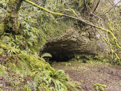
Situated in Ilston Cwm to the south of the village of Ilston near Parkmill. The large entrance can be easily seen on the southern side of the valley and can be approached from the village passing the churchyard to the cwm.
The large entrance to the cave provides a rock shelter in Ilston Cwm. Inside a low crawl excavated by the Taylors can be followed for about 10 metres to break through point where a crawl over fallen blocks leads into the First Chamber which has very shattered with walls and roof composed of wedged boulders. A gap through on the right leads into the Second Chamber which is formed in nice solid water-worn rock and is some 13 metres long, up to 4 metres wide and in one place the roof rises to 5 metres. From here an ascending passage can be seen in one wall but is too high to reach without aid. From this chamber a low passage leads to a Third Chamber which like the first contains many fallen blocks. There are several possible leads in the cave, but the logistics of spoil removal has meant that they have not been dug further.
Ilston Cwm Main Sink
Length 3 mAltitude 37 m
OSGB Grid Reference SS 55804 90173
WGS84 Grid Reference 51.591901 -4.082999
Sink photo Location mapCCR entry
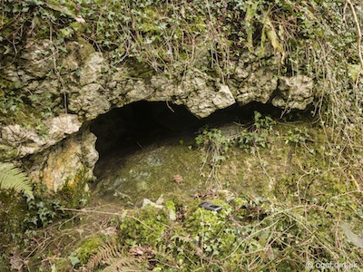
The Ilston Cwm Main Sink is clearly visible from the footpath and is seen on the far side of the Ilston stream. During the drier months of the year all the water in the stream will be engulfed in the area of this sink, while downstream of the sink the streambed being dry until the stream from the Courthouse Cwm reaches the Ilston Cwm stream bed.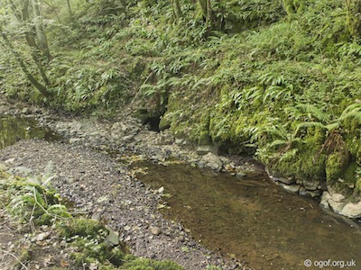
The Ilston Cwm Main Sink is located on the west side of the stream about 300 metres south of the church. The sink which takes all the flow of water of the Ilston stream in normal conditions enters a short section of passage in the rock at the side of the stream. The low passage can be entered and followed for a few metres before it becomes too low for further progress and is blocked by boulders. A dye test was carried out at the site by Richard Baynton where 100 g of fluorescein dye was placed in the sink but the dye was not seen at the Trinity Well Rising as expected. A second test with 50 g fluorescein and using charcoal detectors also proved negative.
Ilston Cwm Upper Rising
Length 0 mAltitude 32 m
OSGB Grid Reference SS 55923 90083
WGS84 Grid Reference 51.591123 -4.081245
Rising photo Location mapCCR entry
The Ilston Cwm Upper Rising disgorges quite small flow welling up from quite deep and is only witnessed when groundwater levels are high.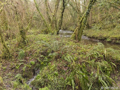
The Ilston Cwm Upper Rising is a small rising located just to the northeast of the confluence of the Courthouse Stream with the Ilston Cwm Stream. The Ilston Cwm Upper Rising is an odd little feature where the water emerges from an area of raised ground that is surrounded by the Ilston Cwm stream on one side and on the others by the channel that takes the flow of the water down into the main Ilston Cwm stream. The water must be forced up from some depth to resurge at this point.
Courthouse Lower Rising
Length 0 mAltitude 33 m
OSGB Grid Reference SS 55977 90084
WGS84 Grid Reference 51.591145 -4.080466
Rising photo Location mapCCR entry
The Courthouse Lower Rising is a small resurgence of water that flows a few metres to meet up with the flow of the main Courthouse stream.
The Courthouse Lower Rising is located just inside the remains of the boundary fence a few metres upstream from the junction with the Ilston Cwm stream. The water from the Courthouse Lower Rising wells up on the north side of the Courthouse stream from a hole that is covered over with mesh. The water flows for about 2 metres to join the main flow of the Courthouse stream that then joins the Ilston Cwm stream a short distance away.
Courthouse Main Flood Rising
Length 2 mAltitude 35 m
OSGB Grid Reference SS 56019 90045
WGS84 Grid Reference 51.590915 -4.079857
Rising photo Location mapCCR entry
The Main Flood Rising for the Courthouse stream emerges from a low rocky bluff on the south side of the Cwm.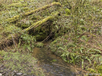
The Courthouse stream can be followed up from the junction with the Ilston Cwm Stream to first pass the Lower Rising and then after another 70 metres the Main Flood Rising is seen on the right, with a dry stream bed continuing up the cwm. The Courthouse Main Flood Rising is located on the south side of the cwm from where the water emerges and flows for about 4 metres before it joins to the main stream bed. The water emerges from a one metre wide fissure that is only a few centimetres tall. The passage is open for at least two metres but too small to enter without excavation.
Courthouse Cave 1
(3 small caves)
Length 17 m totalAltitude 49 m
OSGB Grid Reference NGR SS 56014 90091
WGS84 Grid Reference 51.591218 -4.079936
Entrance A photoEntrance B photoEntrance C photo Location mapCCR entry
Courthouse Cave 1 is actually a group of three small caves located close together in the cliffs on the north of the cwm.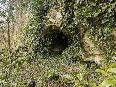
This is a group of 3 small caves located near the base of the cliffs about half way between the two Courthouse risings and 25 metres above the Courthouse stream.
Courthouse Cave 1 A NGR SS 56014 90091 Alt 49 m Length 10 m
Courthouse Cave 1a is found on the right with an entrance 60 cm high and 60 cm wide with a 5 metre long passage that ascends at about 45°. At the end, the passage flips back on itself, again ascending at 45° and heads towards the cliff line. The passage becomes too small, but daylight can be seen through a phreatic tube. In the entrance passage on the left, near the start is a low passage, 2 metres long which branches into two, both choked after a short distance.
Courthouse Cave 1 B NGR SS 56001 90092 Alt 49 m Length 3 m
Courthouse Cave 1b is found 7 metres to the left of the first cave with an entrance 1 metre high x 2 metres wide. The small ascending passage goes for just over 3 metres before becoming too tight.
Courthouse Cave 1 C NGR SS 56001 90092 Alt 48 m Length 5 m
Courthouse Cave 1c is found about a metre to the left of the second cave. This is a small tube about 25 cm high and 20 cm across descending at about 45 degrees for 5 metres. This passage appears to end close to the cliff face.
Courthouse Cave 2
Length 10 mAltitude 59 m
OSGB Grid Reference SS 56076 90047
WGS84 Grid Reference 51.590738 -4.079023
Entrance photo Location mapCCR entry
Courthouse Cave 2 is the only one of this series of caves located on the south side of the Courthouse stream. The cave is located about 17 metres upstream from the Main Flood Rising and 10 metres up the south side.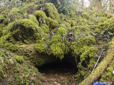
Courthouse Cave 2 has an obvious entrance on the southern side of the valley in the shape of a prominent phreatic passage formed along a bedding plane. The entrance is 1 metre high and nearly 2 metres wide. After 5 metres an earth bank is reached, a 60 cm climb leads to a chamber 1 metre high and 4 metres across containing some fossil stalagmite over a mud floor. The passages leading out of this chamber are all choked.
Courthouse Cave 3
(2 small caves)
Length 5 m totalAltitude 65 m
OSGB Grid Reference SS 56098 90065
WGS84 Grid Reference 51.591156 -4.078713
Entrance A photoEntrance B photo Location mapCCR entry
Courthouse Cave 3 is a site that consists of two small caves located close together on the north side of the cwm. The cave is located on the northern bank about 20 metres upstream from Courthouse Cave 2 and at a height of 15 metres above the stream.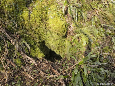
Courthouse Cave 3 A NGR SS 56098 90065 Alt 65 m Length 3 m
Courthouse Cave 3a consists of a steeply descending passage with earth floor that leads to a squeeze 30 cm wide x 20 cm tall where the passage can bee seen to continue beyond.
Courthouse Cave 3 B NGR SS 56097 90082 Alt 65 m Length 2 m
Courthouse Cave 3b lies about 10 metres to the east of the first cave and has a small triangular entrance. The entrance is about 60 cm tall and only 25 cm wide at its base, but can be seen to open out further in. The floor of the cave possibly could be dug to gain entry and to investigate further.
Courthouse Cave 4
Length 20 mAltitude 63 m
OSGB Grid Reference SS 56201 90134
WGS84 Grid Reference 51.591652 -4.077256
Entrance photo Location mapCCR entry
Courthouse Cave 4 is the most significant of this series of caves, with a small entrance leading down into a sizeable chamber with two large passages leading off. The cave is located 25 metres upstream from the Main Sink, the cave is 10 metres north of the stream and with a rocky outcrop 20 metres above.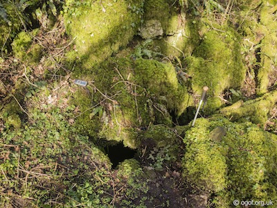
The entrance of Courthouse Cave 4 is an almost square hole in the floor amongst some large mossy covered boulders. From the entrance there is a 3 metre drop which leads to a chamber 2 metres high with a roof formed of boulders. To the right is a passage that is 7 metres long which appears to be heading out towards the side of the cwm and to the left is a passage that is about 8 metres long. This is an interesting cave that may reward further investigation.
Courthouse Cave 5
Length 5 mAltitude 65 m
OSGB Grid Reference SS 56203 90139
WGS84 Grid Reference 51.591697 -4.077209
Entrance photo Location mapCCR entry
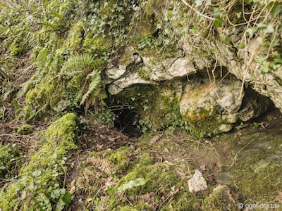
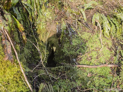
Courthouse Cave 5 is a small cave located near a rocky outcrop on the north side of the cwm. The cave is located 7 metres to the east and about 3 metres above Courthouse Cave 4, the entrance faces the stream and is very easy to spot.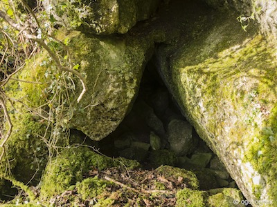
The entrance to Courthouse Cave 5 is a one metre x one metre triangular entrance that leads to 5 metres of passage. The walls are of water-worn limestone and the floor is of jammed boulders and the passage height decreases quickly. Near the end of the passage is a crawl that is 40 cm wide and 20 cm tall that can be seen to go on for 3 metres.
Courthouse Upper Sink
Length 0 mAltitude 53 m
OSGB Grid Reference SS 56228 90125
WGS84 Grid Reference 51.591578 -4.076862
Sink photo Location mapCCR entry
The Courthouse Upper Sink is a minor feature located near the head of the cwm below Courthouse Farm. Near the end of the wooded cwm the sides of the valley level out and a meadow is reached with the stream flowing down the south side of it. The Courthouse Upper Sink is located about 70 metres downstream from the meadow.
The Courthouse Upper Sink is quite a small sink, located on the south side of the stream and often clogged up with brushwood washed in by the floods. Most of the water flows downstream past this site.
Courthouse Main Sink
Length 0 mAltitude 50 m
OSGB Grid Reference SS 56204 90115
WGS84 Grid Reference 51.591482 -4.077205
Sink photo Location mapCCR entry or CCR entry
The only previous records of the speleological sites below Courthouse Farm were included in Tony Oldham’s Caves of Gower. Tony recorded two sinks below the Upper Sink, named the Middle Sink and the Pram Sink which was recorded as being 25 metres upstream from the Middle Sink. On a site visit near the end of winter with high groundwater and little recent rain, only one sink below the Upper Sink could be located, this engulfing all of the remaining stream. This will undoubtably be either the Pram or Middle sink recorded by Oldham, with the other not evident in the conditions encountered on the visit. I have referred to this site here as the Main Sink.
The Courthouse Main Sink is located about 50 metres downstream form the Upper Sink and at the time of visiting was taking the whole of the remaining stream, the streambed being dry below all the way down to the Main Flood Rising. The whole of the flow of the stream is engulfed between fissures in the rocks on the south side of the cwm.

Trinity Well - Ilston Cwm
Ilston Cwm Lower Cave
Length 10 mAltitude 39 m
OSGB Grid Reference SS 55689 89991
WGS84 Grid Reference 51.590236 -4.084583
Entrance photo Location mapCCR entry
Ilston Cwm Lower Cave is found on the northern side of the cwm overlooking the stream just before the Killy Willy Sinkholes are reached. The cave is located downstream from Ilston Church, the cave is in an ivy covered rock outcrop on the northern side of the cwm about 70 metres downstream from the second footbridge over Ilston stream and 15 metres above the valley floor.
Ilston Cwm Lower Cave has an obvious entrance 1.2 metres high by 1 metre wide which shows signs of having been excavated. Inside the cave the passage gently rises and is 1 metre high and has a compacted mud floor and reduces in height gradually until after 7 metres there is a slight corner to the left. From this point the passage is flat out and after 3 metres it ends in an upward slope.
Ilston Cwm Lower Sink
Length 0 mAltitude 29 m
OSGB Grid Reference SS 55693 89952
WGS84 Grid Reference 51.589887 -4.084509
Sink photo Location mapCCR entry
The Ilston Cwm Lower Sink is a small sink that will only be evident under certain water levels and flow conditions. The sink is located in the northern bank of the Ilston stream a short distance upstream from the Killy Willy Sinkholes.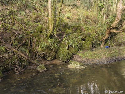
The Ilston Cwm Lower Sink is a series of fissures in the dipping beds of the rocks that form the northern bank of the stream a short distance from the Killy Willy Sinkholes. Under low flow conditions the Killy Willy Sinkholes will take all of the flow of water entering this part of the stream, but in higher flow conditions when the Killy Willy Sinkholes are inundated with water then the stream level rises to overflow into this sink too. The author suspects that the two sites will be closely linked.
Killy Willy Sinkholes
Length 0 mAltitude 29 m
OSGB Grid Reference SS 55687 89933
WGS84 Grid Reference 51.589714 -4.084588
Sink photo Location mapCCR entry
The Killy Willy Sinkholes are a series of fissures in the bed of the Ilston Cwm stream where water will sink. In normal and dry conditions the water that flows from Courthouse Farm stream and joins the dry Ilston Cwm stream bed will then flow downstream to sink at this point. The Ilston Cwm stream bed will then be dry until the Trinity Well Rising meets the Ilston Cwm Stream a short distance below the chapel ruins. The Killy Willy Sinkholes are located about 250 metres downstream from the point that the stream from Courthouse Farm joins the main Ilston Cwm stream.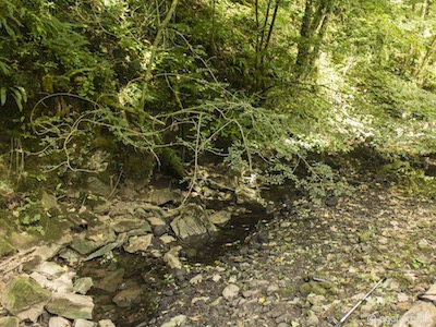
At the Killy Willy Sinkholes under drought conditions, the Ilston stream disappears completely into cracks in its bed and does not appear again until the Lower Resurgence. Under normal conditions some of the the stream reappears at the Killy Willy Rising, although during wet periods the sink is inundated with water and the surface stream flows beyond these sinks and can be seen throughout the cwm.
Killy Willy Rising
Length 0 mAltitude 24 m
OSGB Grid Reference SS 55291 89675
WGS84 Grid Reference 51.587095 -4.090193
Rising photo Location mapCCR entry
The Killy Willy Rising is a small resurgence located a few metres above the Ilston Cwm stream that will only flow in high groundwater conditions. The rising is located about 5 metres to the west of the Ilston Cwm stream where its small outflow descends the muddy bank to flow into the stream.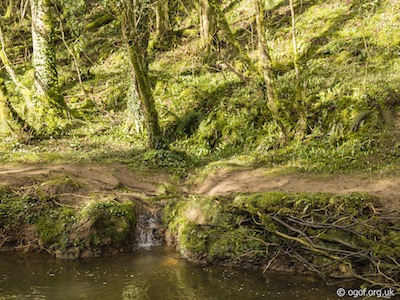
The Killy Willy Rising is found at the foot of the western slopes of the Ilston Cwm where it rises from a rocky hollow. The water then flows for about 5 metres before it cascades down the 1 metre high muddy bank of the stream. The rising is only evident in high groundwater conditions and dries up completely in summer.
Trinity Well Rising
Length 0 mAltitude 20 m
OSGB Grid Reference SS 42578 93652
WGS84 Grid Reference 51.585296 -4.089927
Rising photo Location mapCCR entry
The Trinity Well Rising is the dominating feature at the bottom of Ilston Cwm. The restored ruins of the first Baptist Chapel in Wales marks the resurgence of the water from its underground traverse of the valley. The area is easily accessible via the public carpark behind the Gower Inn and footpaths that guide a route up the valley.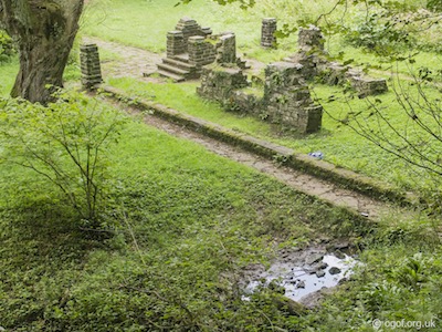
The Trinity Well Rising is the water source used for the first Baptist Church in Wales constructed in 1649-60 and to honour the memory of its founder John Myles. At this site there are some ruins of the Chapel with a commemorative plaque to honour the site. The ruins are the site of the Pre-Reformation Chapel of Trinity Well and is claimed by tradition as a meeting place of the above Cromwellian Church. The Trinity Well Rising is located in Ilston Cwm about 500 metres upstream from The Gower Inn, public house. The well is of religious significance and has been capped with the outflow forming a tributary that meets the main Ilston Cwm stream after about 100 metres.
The water from the Trinity Well Rising emerges from the base of the valley side behind and to the south of the ruins of the old Baptist Chapel. No hydrological link to the main sink of the Ilston Cwm Stream has been proven, but is suspected that at least some of the water originates from the Killy Willy Sinkholes nearly 900 metres upstream.
Ilston Cwm Lower Rising
Length 0 mAltitude 19 m
OSGB Grid Reference SS 55294 89400
WGS84 Grid Reference 51.584824 -4.090037
Rising photo Location mapCCR entry
The Ilston Cwm Lower Rising is a small rising that will dry up in drought and low flow conditions. The Rising is located near the end of the tributary that flows from the Trinity Well Rising to join the Ilston Cwm stream about 100 metres below the chapel ruins. The rising is found about 4 metres to the east of the tributary stream and only about 10 metres up from the confluence.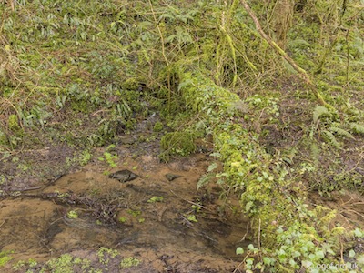
The Ilston Cwm Lower Resurgence is a small outflow that completely dries up in low flow or drought conditions.
Disclaimer
The photographs and information of this page has been provided to help cavers planning trips. Caving can be a dangerous activity, if you are interested in exploring caves please join a caving club so you can enjoy a safe introduction to this sport. Local caving clubs are listed on the links page or you can visit the 'New To Caving' website for more options.If you feel that any of the information is incorrect or should be updated please contact us.
Cave Conservation Code
- Cave with care and thought for the environment.
- Disturb nothing whether living or geological.
- Avoid touching formations.
- Keep to marked routes and never cross conservation tapes.
- Take nothing but photographs.
- Do not pollute the cave, leave nothing behind.
british-caving.org.uk
Download leaflet
